
Trace Nixa Street Records by Address
A Nixa street search works best as a chain, not as a claim that one public record identifies every person at a home. The county parcel service can connect an address to a parcel identifier, a situs location, a legal description, and a deed book or page reference. The assessor-style name and address fields are useful ownership or tax clues. They do not establish that the named person, or every member of a household, currently lives at the physical location.
Use the address first, then keep the parcel facts with each result. The recorder can tie the parcel to a title transfer. A voter record can be checked only with the exact identity fields required by Missouri's public lookup. Older sources can add an occupancy clue. Each source has a different job, which avoids turning a deed or a map label into more proof than it provides.
- Locate the street number in the Christian County GIS parcel service and record the PID, situs, subdivision, legal description, and deed reference shown.
- Compare the parcel's situs field with its owner or mailing-style address fields. Keep both, but do not treat a tax correspondence address as an occupancy finding.
- Use the parcel's legal description or deed book/page to search the Christian County Recorder iCounty service for the transfer trail.
- For a known individual, use the Missouri voter lookup with the required registered name, date of birth, last four SSN, and Christian County selection.
- For an earlier address connection, compare the deed interval with archival, obituary, census, or directory material instead of assuming a current parcel screen preserves old occupants.
Note: Save the source and access date beside each address fact so a later map or title change can be recognized.
Start Nixa Streets With a PID
Christian County's public GIS is the closest official starting point for a Nixa street directory search. The service has Parcel and Address Point layers, plus a separate assessor-data service with Owner Name and Owner Last Name layers. A conventional county property-search form was not located in the inspected official sources. That distinction matters: use the map's identify and query tools, not an assumed text-box workflow.
The parcel layer exposes a durable PID alongside parcel number, owner-style name, street and mailing-style fields, ZIP, deed book/page, legal description, subdivision, acreage, assessment totals, and survey geography. The public service also supports pagination, ordering, statistics, SQL expressions, and distance queries. Those technical options can narrow a map inquiry, but the returned parcel attributes remain land-record data rather than a resident roster.
| GIS field or control | Use in a Nixa street search |
|---|---|
| Parcel number or PID | Identifies the parcel and helps hold the search together when an address changes. |
| Address Point or address fields | Locates a street address or mapped address point where the layer supports it. |
| Owner Name or Owner Last Name | Provides a map-layer ownership clue in the assessor data service. |
sit_stnm and sit_city | Identify the situs street and city fields for the physical parcel location. |
deed_bkpg and leg_des | Carry the deed reference and legal description into recorder research. |
| Subdivision and districts | Place a street in map context, including corporate limits, zoning, school, fire, road, ward, and precinct layers. |
The visible service metadata does not provide an official user instruction for PID formatting. Copy the value as displayed. It is safer than retyping a parcel number from memory, especially when several streets use similar names or a parcel has been split.
Read Nixa Situs and Mailing Fields
Nixa address research has three separate location concepts. The situs is the physical location of the parcel or structure. The mailing-style address may be where tax correspondence goes, including a place outside Nixa or Christian County. The legal description is the survey or subdivision language that connects the land to a deed. A parcel can have all three without proving that the mailing recipient occupies the situs.
This distinction matters on the same named street as much as it does between streets. A parcel may show a trust, estate, business, or owner as its name field and may have a different correspondence address. Read it as ownership and tax evidence. When a street number, road spelling, or lot configuration changes, carry the legal description forward before deciding that two entries refer to different places.
- Parcel or PID
- A county map identifier for a tract. It is the practical link between a map result, assessment-style fields, and deed references.
- Situs address
- The physical street location of the parcel. In the GIS data, situs street and city are distinct from mailing-style address fields.
- Plat
- A recorded map that can show a subdivision, lot, block, easement, or right-of-way relationship.
- Criss-cross directory
- An address-first directory index. It can supply an historical address clue, but it does not replace a Nixa-specific current record.
Note: The recorder requires a legal description for an instrument; a street address alone is not accepted as that description.
Map Nixa Streets and Boundaries
The City of Nixa Community Map supplies the street context that a county parcel card does not. Its documented layers include city boundaries, lots and addresses, street names, council districts, zoning, subdivisions, available single-family lots, sidewalks, snow routes, mosquito-fogging areas, school boundaries, and sinkholes. The layers are hidden by default and can be turned on through the map's crossed-out eye control.
The City of Nixa Community Map screenshot shows why a street directory search should separate road location from municipal status.

Use the Community Map to see whether a Nixa mailing label sits within the city boundary and which subdivision or district layers surround it. Then use the county parcel service for the ownership and legal-description bridge. The map is useful context, not a survey and not a list of street residents.
Follow Nixa Deeds by Legal Description
The Christian County Recorder's iCounty landing page names Recorder Kelly Hall and provides account registration, but its search fields and online historical cutoff were not visible before login. Registered access has no image preview; the displayed service also lists paid day and monthly subscriptions, printing charges, and different preview terms. Ask the Recorder at 417-582-4360 about the earliest searchable year, public-terminal hours, and older deed books or microfilm before treating the online result as complete.
The Christian County Recorder iCounty screenshot documents the account-based entry point for a Nixa street directory deed search.
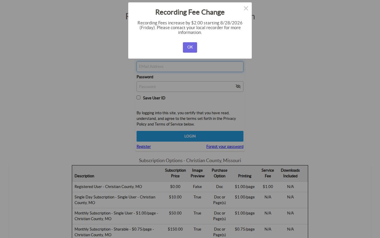
Move from address to parcel facts, then to the current deed. The purchaser is the grantee and the seller is the grantor. Search the seller as grantee in the earlier transfer, and carry forward the lot, block, subdivision, metes-and-bounds language, or prior book/page. The current street address is a finding aid. The legal description is the steadier title key when a tract was replatted or divided.
Recorder instruments can include deeds, deeds of trust, releases, assignments, liens, plats, easements, rights-of-way, affidavits, and probate-related conveyances. A deed establishes a title transfer, not a household list. Image access may depend on the iCounty subscription, while the Recorder counter is the documented fallback when the online window does not reach the needed period.
Date Nixa Street Changes With Permits
Nixa building-permit data and reports add a date layer to street research. The city publishes detailed monthly reports for 2022 through 2026 and retains a single-family start series from January 2003 through December 2022. That series records 3,843 new single-family homes. It is a useful way to date neighborhood growth without equating permits with residents.
Nixa requires permits for many new-construction and alteration projects, including remodeling, accessory structures, fences, pools, decks, storm shelters, and commercial infill. A record responsive to an address request may help identify a project type or timing. The published reports do not promise a searchable historical owner index, original-owner information, inspection history, or utility account information.
For a permit absent from the reports, use the City's open-records request process and specify the street address, date range, and record type. Planning and zoning files can also preserve annexation, rezoning, lot-split, plat, easement, and development context. Keep those filings tied to the tract or subdivision rather than assuming a later address captures the full history.
Note: A construction record dates work at an address, but it does not identify everyone who lived there.
Nixa Voter Records Are Not Street Browses
Missouri's public voter portal is an exact identity check, not a Nixa street directory. It requires first name as registered, last name, date of birth, the last four digits of the SSN, and county. Select Christian County for Nixa. A failed result can reflect a different registered spelling, date of birth, SSN, or county rather than proving that the person was never registered.
RSMo 115.157 identifies public voter fields and a Sunshine Law route for specified information, subject to exceptions and fees. The inspected materials did not identify a current Christian County street-format voter-file order form, price, or delivery format. The Christian County Clerk is the local election authority and can confirm the current procedure. The state lookup itself does not provide an all-voters-on-a-street screen.
Protected addresses must remain protected. Missouri law recognizes court-ordered protections for certain voters, and the Missouri Safe at Home program lets qualifying participants use a substitute address on new government and court records. Do not use a partial result to infer a protected person's physical location.
Nixa Streets Begin at 1881 Crossroads
Nixa's 1881 plat centered on east-west Mt Vernon Road and north-south Main Street. That small geographic fact is useful when an old deed, newspaper line, rural route, or post-office reference does not look like a current street address. The City's history of Nixa places the first residence and post office in 1873, the formal name in 1881, and incorporation as a fourth-class city on June 7, 1945.
Historical searches should retain original spellings and try Mt Vernon, Mount Vernon, abbreviated street suffixes, road names, nearby landmarks, and the legal description. No official Nixa street-renaming or renumbering schedule was located in the inspected sources. A documented 1947 renumbering in Springfield is an adjacent-city example, not evidence of the same change in Nixa.
The safest historical conclusion is often modest: a record may place a person, a road, or a tract at a particular time without proving a continuous address sequence. The 1881 plat and a legal description are better bridges than a guessed modern number.
Compare Nixa Address-Keyed Records
No single Nixa street directory combines ownership, current residence, building history, and past occupants. The following records answer separate address questions. Start with the public GIS and then choose the follow-up route that matches the fact you need. That approach keeps a parcel, a title transfer, a permit, and a voter record in their proper roles.
| Address record | Nixa or county keeper | Street-level signal | Access route |
|---|---|---|---|
| Parcel and address layer | Christian County GIS | PID, situs, owner-style fields, legal description, subdivision, deed reference, acreage, and values | Public map and REST services |
| Recorded deed or plat | Christian County Recorder | Grantor, grantee, transfer date, legal description, book/page, and related instrument | iCounty account or Recorder counter |
| Building permit | City Building and Development | Project activity and timing where the underlying address file is released | City reports, myNixa, or a records request |
| Planning or zoning file | City of Nixa | Annexation, rezone, plat, lot split, easement, or development context | myNixa or City request |
| Voter record | Missouri Secretary of State and County Clerk | Individual registration check or statutory request route, with protections and limits | Exact-identity lookup or Clerk confirmation |
When a ZIP has narrowed the search area but not the street, the Nixa ZIP code directory separates postal coverage from city-limit status. Return to parcel and legal-description fields for the address-level record chain.
Nixa Street Directory Limits
Public parcel maps do not provide a complete household inventory. They do not establish every resident, guest, delivery recipient, utility customer, or other unverified occupant connected with a location. A name on a deed, voter match, business record, or correspondence field answers a narrower question. Sensitive personal identifiers, protected voter addresses, and motor-vehicle address data are not material for a public street search.
If a record looks wrong, contact the appropriate custodian with the parcel identifier, instrument or case reference, and the specific correction needed. Do not alter a copied record or publish a protected address as though it were an official update. A current public record can be incomplete, delayed, or tied to a different role than residence.
Lawful personal use. Nixa street and address records support personal research, family-history, property, and civic questions. Never use them to stalk, harass, intimidate, defraud, or harm another person.